As we came down I-25 from Denver, we could see the snow capped Pike's Peak. That mountain really stands out! We camped at the KOA in Fountain, about 8 miles south of Colorado Springs. Definitely a handy location - groceries, church, McDonalds :-) , fuel and Walgreens just a mile or so away. We decided to hit the Pioneer Museum and the McAllister house museum on Saturday. To our delight we found a Bruegger's Bagels and so had breakfast there. The city of Colorado Springs has beautiful wide streets, and on Saturday parking was no problem. Pioneer Museum was interesting, but it was so cold inside you could hang meat in there! We lasted about 2 hours and then headed to lunch and a stop at the McAllister house, where the docent was very knowledgeable and eager to share information. Mr. McAllister came west to assist General Palmer in laying out and overseeing the building of Colorado Springs. His home was comfortable, but not elegant.
Sunday we went to Garden of the Gods, a FREE park donated to the city by the family of the man who owned it. The park has several hiking of trails of various lengths and we chose two to walk. In some areas the formations reminded me of Bryce Canyon's hoodoos. Some of the rock formations were begging to be climbed, and there were many people either on their way up or down. From Garden of the Gods we drove a short distance to Seven Falls. This is the only waterfall in Colorado to make National Geographic's list of International Waterfalls. There are 224 steps to the top of the falls if a person is up for the challenge. For those of us who were not so inclined, a mountain elevator whisked us up to the Nest Observation Platform where we had a perfect view of all 7 sections of the falls.
Monday we drove 20 miles north to the US Air Force Academy, and we were lucky in that we were in time to watch the noon formation of cadets. As we arrived at the Visitor's Center, the receptionist suggested we take the 1/3 mile walk to the Air Force Chapel overlook, as the cadets would be forming in about 15 minutes. It's a once a week salute to visitors who come to the Academy. It was thrilling to watch the 4000 cadets march in review, and acknowledge us as they passed our perch. The chapel is striking - very modern with an aeronautical uplifting feel. The Protestant chapel is on the main floor, with Catholic, Jewish, and Buddist chapels below.
Tuesday we drove to Pueblo (38 miles south) to tour the Rosemount house museum. It is a 37-room, 24,000 square foot mansion which was the family home of John and Margaret Thatcher. The property was named for her favorite flower - the rose. The house was built between 1891 and 1893 at a cost of $100,000 dollars. It was beautiful, and nearly all the furnishings, wall and window treatments, decorative arts and paintings are original to the home. It has Tiffany chandeliers throughout the house. Even though large, it FELT like a family home.
We got home from Pueblo about 1:30 and decided to visit the Miramont Castle Museum in Manitou Springs, a short drive north of Fountain. The castle was built in 1895 by Father Jean Baptiste Francolon as a home for himself and his mother. Father came from France to assist the Archbishop, however due to ill health moved to Manitou in 1892. By 1900 the Francolons returned to France, and the Sisters of Mercy purchased the castle in 1904 . A sanitarium was run in the castle until the 1920's after which it became a boarding house for the wealthy. Later it was used for retreats and as a vacation home for the Sisters. In 1976 the historical society bought the property, as it was in the process of condemnation and would have been razed.
Our final sight seeing excursion was on Wednesday afternoon when we went to the Manitou Cliff Dwellings. They are a rare historical treasure. Preserved under a protective red sandstone overhang, the Anasazi cliff dwellings were built more than 700 years ago. We were able to walk through the pueblo as it is one of the most accessible examples of cliff dwellings anywhere. The Anasazi are also known as the Ancient Ones, or the Ancestral Puebloans. These people lived between 1100 and 1300 AD. The site was opened in 1907. There were signs explaining the purpose of each room. Also on site was a small museum.
From here we'll travel to Tulsa, OK. We aren't certain what we'll find there, but we'll share our findings!
Thursday, September 29, 2011
Monday, September 26, 2011
Denver, CO area
We camped at the KOA in Strasburg, CO, about 30 miles east of Denver after a very tiring road trip from Moab, UT. When we hit the Rocky mountains, we ran into rain and drizzle which made driving a real problem, as the windows would get dirty and we'd have to use the washer to clean them off.
The first day we drove 70 miles north to Estes Park and stopped at the historic Stanley Hotel, which is a National Historic site. Early travelers flocked to the hotel and today it is also famous for Stephen King's novel and movie The Shining. The tours of the hotel were booked for the day, so we progressed to Rocky Mountain National Park. We entered through the Fall River Entrance Station at 8240 ft. and took the Trail Ridge Road to the Alpine Visitor Center, the highest visitor center in the USA at 11,796 ft. To reach it we went through a forest area to the tundra at the higher elevations. The highest point we were at was 12, 183 feet. The temperature at the Alpine Visitor's Center was 39 degrees with a stiff wind and when we came out, SNOW FLURRIES! The drive was a camera bug's dream! High snow capped mountains and deep canyons. Most of this road is closed from mid-October to Memorial day, as the snow gets to 20 feet deep in some sections! From the visitor's center we retraced our steps to lower altitudes and took the Bear Lake Road to ....BEAR LAKE! The temperature at the lake was 79 degrees. Quite a difference! We really enjoyed the park.
WE visited two hour museums - the Unsinkable Molly Brown's home and also the Byers-Evans home, both downtown. It seemed every thoroughfare we needed to take was under construction, so parking and getting around town were challenges. In fact it took us 20 minutes to go 8 blocks! NO MORE! We didn't go back downtown the rest of our stay!
Golden was only a short distance on the west side of Denver, and we spent two days there. The first day we visited the Colorado Railroad Museum, and the following day we toured Coors Brewery (yep, 2 glasses of free beer if you wished, or soft drinks). Guess what we chose??? The tour was very worthwhile, and self-paced so you could spend as much time as you liked reading the information or looking down into the production area. The packaging area was the most interesting to me, as I was fascinated watching the parade of bottles and cans into their cartons, and then rolling up the conveyor belts to the shipping area.
From Coors we went to Lookout Mountain to see the Buffalo Bill Cody's grave at the very summit of the mountain. It must have been a real challenge to travel up the mountain when he died. It took us a long time to get to the top with all the curves and switch backs.
IT was a great time in Denver. Oh! Denver is known as the "Mile High City". The reason is that the 15th step of the capitol building is at 5280 feet! How about that bit of trivia?
Wednesday, September 21, 2011
Canyonlands and Arches National Parks
 |
| Capitol Reef - Gibson House |
 |
| Canyonlands |
Canyonlands has three areas -- the one easiest to reach is the Islands in the Sky area where the majority of people visit the cliffs and overlooks. The Green river and the Colorado river join within the park. At that point white water rafters enjoy a wild ride. The second area is called Needles, and is an area of pinacles and hoodoos. Only hikers and those with jeeps or quads can go into that area, as there are no paved roads. The third area is called the Maze, and only primitive hikers and 4-wheel drive vehicles with permits may travel into that area of the park. Islands in the sky is a broad mesa wedged between the Green and Colorado rivers and it acts as an observation tower to look into the canyons below. The area is arid - - it gets only 10 inches of rain a year.
Between Canyonlands and Arches, I enjoyed the latter much more. Perhaps it was because there were well marked trails to the various arches that were fairly easy to travel. We hiked to several arches - the windows arch trail was 1 mile, and had the added bonus of actually having three arches to view. We also hiked to the sand dune arch - an easy .3 mile hike with lots of sand to hike through! AJ would have loved to play in it!!! Skyline arch (shown below) was a 0.4 mile hike and our favorite arch was the Landscape Arch which we hiked at 7:30 in the morning. That hike is probably the most popular one in the park, as by 10:00 a.m. there are NO places to park. An added bonus to that early morning hike was encountering a mule deer grazing about 30 yards from us! The hike was 1.6 miles to the arch with some elevation and gravel surface. There was a short side trip to Tunnel and Pine Tree arches. We liked the park so much that we visited the park three times while we were in Moab!
 |
| Skyline Arch - Arches National Pk |
Sunday, September 18, 2011
Utah National Parks
In my previous blog I talked about Bryce Canyon National Park. Utah has a many more National Parks and we visited four more: Zion National Park, Capitol Reef, Canyonlands, and Arches. Each is unique while being somewhat similar.
Zion National Park is the oldest and most visited national park in Utah and exhibits some of the most spectacular scenery. There are deep sandstone canyons, rock towers , high mesas and plateaus. We hiked the River Trail along the Virgin River which is credited with forming much of the park with its meandering stream. The River Trail was handicap accessible, and therefore very popular with everyone, while the more experienced hikers opted for the Narrows and other more strenuous hikes. We also did the Lower Emerald Pool trail which was also billed as an "easy" trail. It was, in the sense that you didn't have to scoot along slippery bare rock and hike for hours to reach the emerald pool, but it was quite strenuous if going up the side of a large hill bothered you. We were disappointed in the emerald pool -- it was small and scummy. The waterfall we were expecting to see was not the roaring type but merely a weak trickle over the edge of a cliff. The Minneopa Falls in a dry summer has more action that it did. It was nice to be able to look UP at the beautiful canyon walls instead of down as we did at Bryce Canyon.
The bus system made it easy to go from one trail head to another and the buses ran every 10 minutes. It was one of my favorite parks.
Capitol Reef was our next adventure. It's a small national park, but has the honor of having been the west coast of the US in ancient times. The reef was actually the end of the land mass (no Nevada, no California), and the rocks show the ripples of the tides and there are many fossils of aquatic life to view. The reef itself shows the geology of various levels of activity. Unique to the park is the Fruita area which was settled by Mormons in the 1800's. Several orchards of peach, pear, apple, and plum trees are still in the area, as are the home of the Gifford family, the last Mormon family to leave the park in 1969.
We didn't hike any trails in this park, but we did stop and pick enough apples to make an apple pie and still have enough apples for an apple crisp later. The fruit is free for the picking, but we were too late for the peaches and pears :-(
I'll fill you in on Canyonland and Arches in my next blog!
Sunday, September 11, 2011
Bryce Canyon National Park - 9/3/11
 |
| Bryce Canyon, Sept. 3, 2011 |
 |
| Hoodoos |
On Saturday we headed sixty miles north to the Bryce Canyon NP. WOW! The park was established in 1928 and is named after Ebenezer Bryce, a cattleman who settled in the area in 1875. The park sits on a plateau with pines and aspen trees, and as you approach the rim, there's an 8000 foot drop-off into the colorful canyon filled with spindly, pointed rock spires and hoodoo formations caused as a result of ice and rainwater.
As you can see from the Hoodoos picture, the canyon has oranges, yellows, cream and rust colors. Very beautiful! We took a trolley from the Visitor's Center to Bryce Point, and from there we walked along the rim for 1.3 miles to Inspiration Point. As many of you know, I'm not good with heights, and walking a narrow trail along the rim with no protection of any kind was a real test for me. Jack held my hand over most of the trail, and graciously took the outside edge which helped. This hike took about 1 hour, as not only did we walk along the edge, the trail also rose 200 feet! We also stopped to take pictures of the breath-taking sights.
From Inspiration Point we caught the trolley to see the rest of the park, went back to the truck to get our picnic lunch, and went back out to Sunset Point to eat it. We enjoyed watching and listening to the other visitors to the park -- we heard German, Dutch, Japanese and other languages we didn't recognize. The variety of clothing worn by veteran hikers from Europe was also interesting to see.
We traveled UT 12 - a scenic highway from UT 89 to get to the park, and on our way we drove through the huge Dixie National Forest and stopped at the Red Rock Visitor's Center, a recreation area with beautiful red hoodoos, natural bridges, and tunnels through the rocks. It was a wonderful day!
Thursday, September 8, 2011
Grand Tetons National Park
 |
| Mount Moran and Jackson Lake |
I challenged myself by taking a scenic rafting trip on the Snake River. It wasn't white water, it was just right for someone who doesn't relish being dumped into the cold water of the Snake River! The boatman had seven of us on board, and since the raft was not full, spent more time on the river with us and going into areas that a full raft would not have been able to navigate. We saw a herd of elk in the distance and three more bald eagles. Steve, the boatman, also pointed out "scout rock" (do a good turn daily) as the raft had to turn to avoid hitting it. A little humor there :-) The rafting trip on the water was 3 hours, with an additional hour riding to and from the Jackson Lodge, a National Historic site. Rooms went for $250 and up, and cabins $400+ per night. Ohh la la!
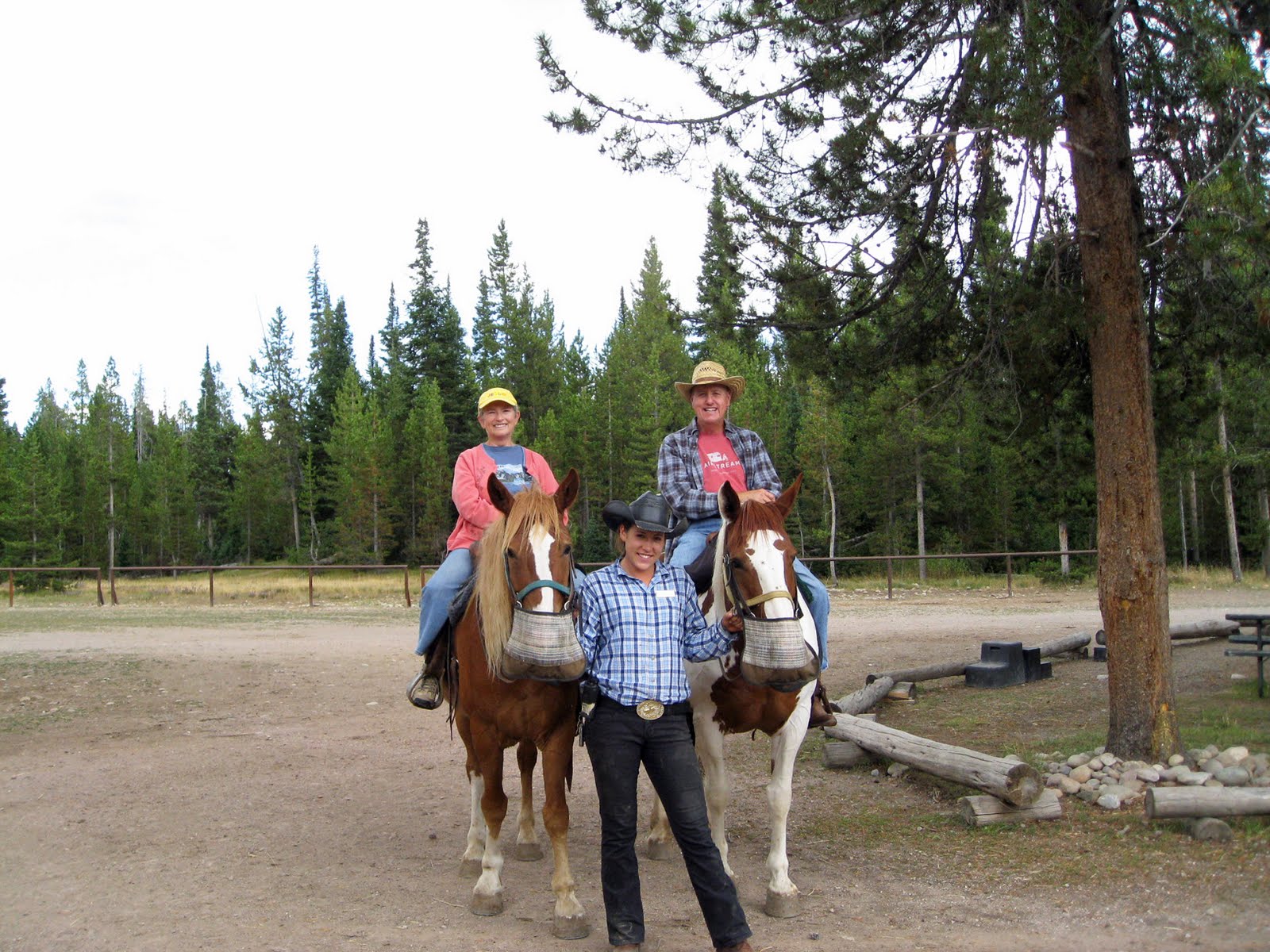 |
| Jean on Opie, Sarah, and Jack on DisneyAdd caption |
Since we were in bear country, we were warned that all food, toiletries, grills, etc. had to be locked up when not in use. Nothing could remain on picnic tables. We had to either put our things into the trailer and lock it, into our car trunks, or into a bear safe container, or we could suspend it 10 feet off the ground between two trees. The food had to be at least 5 feet from either side....like THAT was going to happen! The campground had about 100 campsites, and every night they were full.
It was a great place to camp!
Subscribe to:
Posts (Atom)