Saturday, June 30, 2012

Pictures from Crescent City,Sequoia and Yosemite


The Battery Point Lighthouse, Crescent City CA

Jean crossing to lighthouse at low tide 

Fallen Redwood in Stout Grove near Crescent City


On the rocks at Sequoia NP

Bridal Veil Falls, Yosemite NP

Half Dome and Vernal Falls from Glacier Pt, Yosemite NP


Crater Lake, OR June 28,2012


Thursday was a beautiful day near Gold Hill, OR where we're camping.   We're about 70 miles from Crater Lake NP, and this seemed to be the ideal day to go.   The drive up was beautiful - passing a reservoir with huge lake marina, and pine forests.   We entered thru the south entrance, and stopped at the Visitor's Center to get our maps and information.   There we learned that only the west rim of the crater drive was open, as crews are still clearing the roads on the north and west sides.   There are 30-50 ft. snow drifts left to clear, and most trails are also closed because of snow obscuring the markers, etc.   With budget cuts, the park was unable to hire additional crews to clear the roads, and no overtime.   It takes 8 hours to clear 1/4 mile!  

A massive volcanic eruption 7,700 years ago left a deep basin in the place where a mountain peak once stood.   Centuries of rain and snow filled the basin, forming a deep blue lake whose waters are of unmatched color and clarity.   It's the deepest lake in the US.   The lake is 6.02 miles across, 1943 ft. deep.   The park gets 94 in. of snow in Dec., 104 in. in Jan., and 84 in. each in Feb and Mar.   No wonder those drifts are so big!

Wednesday, June 27, 2012

Crescent City, CA -23 to June 27

We arrived in the rain on Saturday, June 23, 2012.   The campground is very handy, since it's right on Hwy 101.   Checked out churches, Mass times, and settled in for the evening.   Sunday was beautiful, but chilly.   We had breakfast and went to Mass, and then took a 14 mile trip thru the Jedediah Smith State Park and took the Redwood Forest Loop Drive.   What a road!   Hard packed dirt road (one lane in most places) and weaved between the giant redwoods.   There were many opportunities to hike, and we took two.   The first was the Nickerson trail, which took us deep into the redwoods, with all varieties of ferns growning along the trail.   The second was the Stout Grove, which was wider trails and more popular than the previous one. We were awed by the Smith River - beautiful as it cuts between two mountains.  

Monday we woke up to cloudy skies, and by the time we left the trailer it was starting to rain.   Had to find SOMETHING to do that was inside!   Stopped at the Visitors Center and learned about the Battery Point lighthouse, which can only be reached by foot at low tide.   We hustled out to the parking area and made our way across the rocks (in the rain) to the lighthouse for a tour.   The light keeper is a volunteer from Kansas City, MO.  The volunteers come from all over the US and stay a month at the lighthouse.   Their duties include running a gift shop, giving tours at low tide, and of course keeping the light lit!   The living quarters were very comfortable, and there is a modern kitchen with a view to die for!   From the lighthouse we went back into town to the museum and learned about the TWO tsunamis that have hit Crescent City -- the 1965 Alaska tsunami and the 2011 one.   The Alaska one wiped out 29 blocks of the town, and came in during the night.   The 2011 one came during the day, and since the city had taken safety precautions after the first one, it only caused problems at the marina--piling all the boats into one big heap.   Later in the afternoon we went back out in the rain to watch the rescuers feed the "patients" at the Northcoast Marine Mammal Center.  The Center rescues, rehabilitates and releases seals, sea lions and walruses which are washed up along the coast, or are rescued in the sea near land.    They had two adults (one will be released on Sunday),  and 6 baby seals ranging in age from 2 weeks to 8 weeks of age.   They were fun to watch.  Their average stay is 1-2 months.

Tuesday was beautiful, so we drove back down 101 to the Trees of Mystery which had a hiking trail through the redwoods with information on the various strange ones (one truck with 12 other trees growing out of it), the Cathedral tree (5 redwoods together - often the site of weddings), and the huge brotherhood of man tree.   There was a gondola which took us to the elevation of 700 feet with beautiful view of the mountains in the distance and in the other direction, the Pacific.   On the way back down we were treated to fables of Paul Bunyon carved with a chainsaw.   There was a huge statue of Paul and Babe in the Parking lot, which reminded me of the ones in Bemidji, MN.   This Paul talked to you, waved, and winked.   He evidently could hear what people were saying, and so called the kids by name, answered questions, etc.   What fun!
We drove a few miles farther south and found the "Drive Thru Tree", so I took the pictures, while Jack maneuvered the truck thru the trunk of the large redwood.   He said that even with the mirrors pulled in, the mirrors touched the tree as he drove through.  

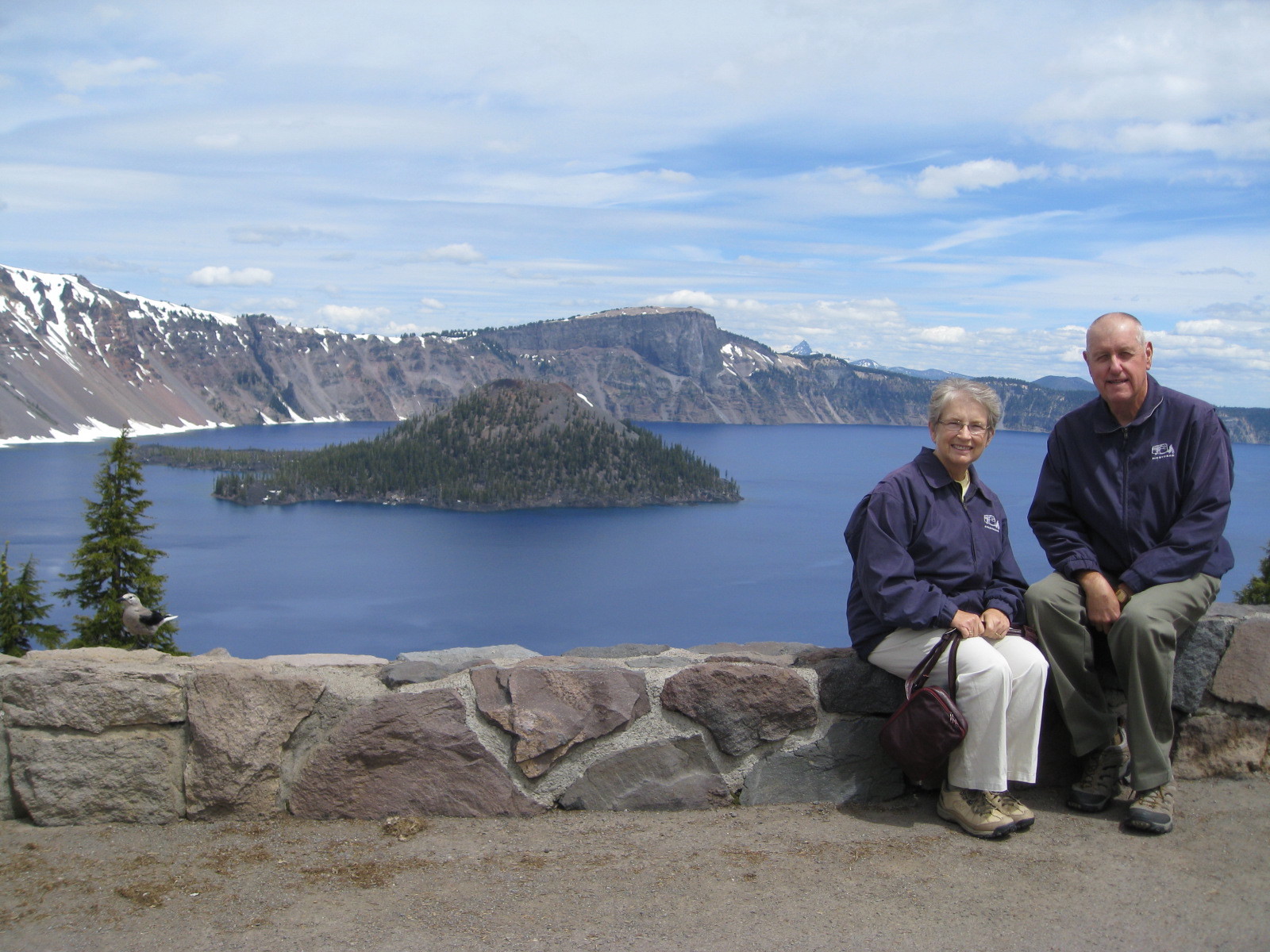
Today (Wednesday) we drove hwy 199 - the Redwoods Highway- to our new campsite between Medford and Gold Hill, Oregon.    It was a beautiful drive!


Monday, June 25, 2012

Oroville, CA

We left the sandy and dusty KOA of Coarsegold and traveled north to Oroville, CA to visit the Hennekers.   Doris and I were Girl Scout leaders together in the 1970's and have kept in contact over the years.   I wrote at Christmas and indicated we were going to be in California this summer, and she invited us to visit.  (Bet she never dreamed we'd take her up on it!) The oleanders and other flowers growing in the medians of hwy 99 and 5 were beautiful!   It definitely cut down on the trash, as they filled the median with flowers!  Our GPS system pulled one of it's "fastest route" tricks, and there was a time when I finally called the Oroville KOA to see if we were even close, as there were orchards on both sides of the road and we had no clue where we were.   We were assured that while not the usual way to the KOA, it was definitely the shortest!  

The KOA was on the Feather River Casino and reservation property and our site was awesome!   We had a cement pad and patio, with a fancy gas grill (propane provided), a metal umbrella table and 4 chairs, a wooden rocker and a swing.   Wow!   The bathrooms had heaters and the dressing area was huge.   VERY NICE!   Even nicer was the fact that walking over to the casino, we could get breakfast and our evening meal for reasonable prices.  

The next day we visited with the Hennekers and enjoyed apricots off their tree in the back yard.   Jim drove us to the beautiful lake formed by the huge reservoir /dam built in the 1960's, and we toured some of the city before heading back to their house where Jim fixed dinner on the grill.   The next day we visited the Chinese temple and the Lott house and the Pioneer museum.  After dinner at the casino we said our goodbye and the next morning left for Crescent City, on the coast 17 miles south of the Oregon border.

The trip was long and more twists and turns on 299.   The scenery was beautiful, but by the time we reached highway 101 I was more than ready for a straight road!   We ran into rain on our way to Crescent City and it rained all the way to our campground.  

Tuesday, June 19, 2012

June 8 - 19, 2012

We arrived at the Coarsegold KOA about 4:30 in the afternoon, after having come through Yosemite National Park on the Tioga Road.   The entrance to the park at Tioga Pass was 10,000 feet!   Yikes!  And we were on that road for the majority of the day.   We only drove 180 miles today, but oh what a road!   Up and down, curvy, winding roads with fabulous scenery.   The speed along that road was 45 mph.   We stopped and took tons of pictures.    By the time we left the park, I was feeling a bit queasy.    Our campsite at the KOA was on a knoll, with delightful breeze.   There were only 3 campers on the knoll until Friday.   The town of Coarsegold is small, with very few amenities.   We drove 8 miles north to Oakhurst for breakfast, groceries, and church.  

We actually went into Yosemite 3 times.   The first was on our way through the Tioga Pass, the second was to visit the Yosemite Valley with it's Yosemite Falls, El capitan mountain, and bridalveil falls.   We visited the museum and the Indian village and the visitor's center and the store.   The final trip in was to visit the Mariposa Grove of giant sequoia trees.   The most famous is the Grizzly Giant (2,700 yrs. old, 200 ft. tall, and its base is 31 ft. across).   We hiked (uphill, of course!) to the tree and then went to the California Tunnel tree which had an opening through the base to allow stagecoaches to go through it in 1890's.   After lunch we drove up to Glacier point where we had a panoramic view of the valley, the Half dome and Vernal and Nevada falls.   On our way out of the parking lot, a mother bear and two cubs were coming down out of the woods toward the parking lot.   I got a couple really good pictures as we drove by!

With Jack's interest in trains, we went to the Sugar Pine Railroad in the Sequoia National Forest and rode a Jenny-car, a Model T car that was converted into a railroad car used to haul workers to the area that they were working on, or to follow steam trains to put out any fires that occurred along the track.   Another couple from San Diego road the car with us.   We also visited their gift shop, book store, and museum, where we bought a sugar pine pine cone -- a mere 12 inches in length!    They grow stuff  BIG around here!

Our final venture into National Parks was to visit Sequoia and Kings Canyon National Parks, about 2.5 hours from our camp.   The two parks adjoin each other.   We entered the Ash Mountain Entrance.   The 16 miles from Ash Mountain to Giant Forest includes 130 curves and 12 switchbacks.   Slow going!

In Sequoia we enjoyed the Giant Forest where the General Sherman Tree, the largest tree in the world.  It weighs2.7 million pounds and is believed to be 2100 years old.  It's height is 274.9 ft., and its circumference at ground level is 102.6 ft.   The diameter of its largest branch is 6.8 ft.   Every year it adds enough wood to make a 60 ft.  tall tree measuring one ft. in diameter.    It's still growing!  We hiked 0.4 miles down hill to see it....and then back up!   After lunch we continued on the General's Highway to Kings Canyon to see the other very large tree, the General Grant.   This tree measures 267.4 ft tall and 107.6 ft. around.   It was discovered in 1862 and was named to honor US Grant.   This tree is "only" 1,800 to 2,000 years old.   It is called The Nation's Christmas Tree.  

We were very blessed to be camping so close (70 miles) to navy friends we hadn't seen since 1967.   We didn't realize this until we were sitting down and looked at the California map on that first weekend in camp.  A phone call and we planned to go visit them in Lemoore.   How wonderful!  We so enjoyed catching up in person!  On our way south into the Central Valley we were in awe of the vineyards and orchards.   We also discovered a new fruit ...a peacherine.   It's a fruit with smooth skin like a nectarine, but taste like a peach.   Love them!


Saturday, June 9, 2012

Ely, NV June 3 - 7, 2012

We left beautiful Salt Lake City around 10:00 a.m. and drove I-80 to Wendover, NV where we turned south and drove highway 93 to Ely.   I think we saw no more than 10 cars from Wendover to Ely, and there were no rest stops, gas stations, etc.   Very desolate territory!   When we arrived at the Valley View RV Park the clerk told us to "take any site but 68".   We took one that had a tree for shade and proceeded to set up.  

On Monday we walked through the downtown area and enjoyed the murals on the walls of various buildings.  The town had many casinos, but it also had a large number of empty business buildings.   We went back to camp for lunch, and by that time the wind had picked up and at times the gusts were making it impossible to see across the road!   Shades of the dust bowl!   I heard on the tv that some of the gusts were 50 mph!  

Tuesday when we awoke the temp was 53 degrees, after breakfast it was 43 with a stiff north wind.   We planned to drive the 65 miles to the Great Basin National Park so had packed a lunch the night before so we could picnic while we are there.    We stopped at the visitor's center to get a map and see the exhibits before heading for the Mt. Wheeler Scenic Drive.    Mt. Wheeler is over 13,000 feet elevation, but the scenic drive took us to the 10,000 foot level where it was a cold 29 degrees with stiff north wind and SNOW FLURRIES! Brrr.   We brought soft drinks....should have brought hot chocolate.   The "picnic" was held in the truck before starting back to Ely.   When we got back we stopped at the Old Drug Store (true name!) and I had a chocolate soda and Jack had a strawberry malt at their original soda fountain.   The waitress told us that it had snowed for 3 hours in Ely while we were at the National Park.   The snow was all gone :-(

Thankfully it warmed up on Wednesday to a balmy 56 degrees and we went down to the historic train depot and took a ride on the train to an old copper mine and back.   The engine was a diesel, and I was happy to see the engineer was a woman!   The train consisted of a coach, an open car and a caboose.   The
train yard is a working museum and is run totally by volunteers who repair the engines and keep the rolling stock in working order.   They offer several weeks a summer when people come from all over the US to work on the trains.  This site is well-known in railroading circles and has been filmed often.   It was a fun 2 hour ride.

On Thursday we pulled out at 8:45 and drove Hwy 6 to Bishop, CA.   The road was great but there was only one town between Ely and Bishop - Tonapah 168 miles from Ely and 120 miles from Bishop.    One definitely had to watch their fuel gauge!    We pulled into Bishop at 2:00 p.m.

BISHOP, CA

We were only staying for one night, so I talked Jack into dinner "out"....KFC!   We noticed a "bakkery" (their spelling) as we were driving through to get our chicken, and decided to check it out in the morning.  Oh what a delight!   The owner is from the Netherlands, and his "bakkery" had homemade breads, rolls, cakes, and sweet rolls.  YUM!   I had a cherry turnover that was so full of cherries I had them in every bite, and it was HUGE!   After breakfast we hitched up and left town at 9:30.

Sunday, June 3, 2012

Salt Lake City, UT May 30 - June 2

We arrived at SLC Wednesday afternoon after fighting 35 mph winds on I-80 between Cheyenne, WY and SLC.   It was a relief to get off the road!   The check in here was a real hoot.   The young woman who registered us was fun.   Our campsite was shady and grassy and on a asphalt pad.   Nice!  We decided to take a city tour on Thursday afternoon, and spent the morning in camp.

The tour on Thursday was definitely a challenge.   The shuttlebus was full with KOA campers and tourists from various hotels in the area.    As we pulled out of the campground, the lady ahead of me and I noticed very warm air pouring out of a vent along the floor.   Only our side of the bus was affected.   Jack and the man ahead of us notified the the driver, as we drove down the street.   By the time we had been riding for several minutes we were roasting!   He said he'd see to it at the first stop.....20 MINUTES LATER!   When we got off to see the "This is the Place" monument commemorating where the Mormon pioneers came into the valley and Brigham Young said "this is the place", our driver spoke with a van driver behind us (same company), and so several of us piled into the van to continue our tour.   We stopped at the State Capitol and toured the building -- beautiful!   Several brides were there having their wedding portraits done in the polished granite atrium.   When we came out, our new driver, Andrea, offered to pull the van around so we wouldn't have to walk too far, and when she jumped out to open the doors, she had locked the keys in the van!   Our next stop was to be the Lion's House on Temple Square for dinner, so the shuttlebus (which had been fixed while we toured the Capitol) took the others to dinner and returned for us.   Andrea had to wait for an extra set of keys to be brought to her.   Unfortunately, our jackets, sweaters, etc. were now locked in the van!   She appeared after dinner and escorted us to the Conference Center to hear the Mormon Tabernacle Choir's rehearsal from 8-9.   It was wonderful!  
On the way back to camp (all of us back in our shuttlebus), we learned that the choir has 300 members and they may only serve for three years.  

Friday we drove 30 miles to the Kennecott Copper Mine which is the biggest copper pit mine in the world!   It is the ONLY ONE OF TWO man-made structures  that can be seen from the space station.   From the visitor's center we could watch the trucks hauling the ore out of the pit.   There was a museum in the visitor's center so we spent an hour or two viewing videos and learning about the site.   We came back to camp to park the truck, and then took the free shuttle to Temple Square.   We saw a 90 minute movie about Joseph Smith, and toured the conference center rooftop garden and the other areas of the building we hadn't seen the evening before.   We also toured the Beehive house, the home of Brigham Young.  We had heard that there was an observation deck on floor 26 of the Church Office Building so we were escorted up and the guide pointed out various sites.

We went back on Saturday and spent a great deal of time in the Family History Center looking for information on our ancestors.   We were hooked!   Both of us had fun searching for information.   I found the ship roster showing my great-great grandmother emigrating to the US.   Also found my mom's parents wedding information.   Can't wait to continue the search.

Today we pulled out of SLC and drove into Nevada to Ely, a town of about 6000 people.   We plan to stay four days, so will add info as we discover the area.